Democracy for Some: Defining the Indiana Landscape through the Rectangular Survey System

“Drawing of George Washington as Surveyor” in Andrew G. Gardner, “How Did Washington Make His Millions?” Colonial Williamsburg Journal (Winter 2013) accessed http://www.history.org/foundation/journal/winter13/washington.cfm

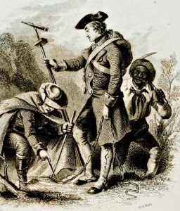
A small group of men made their way through the thick southern Indiana forest dragging chains in their wake. Once in a while, they stopped to score a tree, plant a post, and record their progress. For those residents of the Indiana Territory who witnessed this bizarre parade in the fall of 1804, this group represented vastly different futures. For Thomas Jefferson and other leaders of the young United States, this group of men sent to survey the Indiana Territory represented the spread of democracy. For the indigenous people who first called this land home, the marks cut and burned into the trees represented the impending and permanent loss of that home. Despite their disparate perspectives, both would soon see the redefinition and reorganization of the landscape by the rectangular survey system.

Indiana Historical Bureau, “Indiana Territory,” The Indiana Historian (March 1999), 4, accessed in.gov/history.

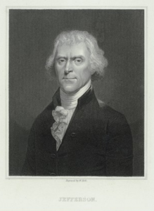
After the American Revolutionary War and via the 1783 Treaty of Paris, the British surrendered their claim to the thirteen colonies and ceded a vast amount of western and southern territory to the young United States. In order to grow the republic and repay war debt, the new government needed a system of organizing this land for sale. In response to these needs, the Continental Congress created a committee chaired by Thomas Jefferson to create a system for surveying the new territory.

Jefferson passionately believed that the system had to make small plots of land available to the individual farmer (as opposed to large plots available only to the wealthy, to speculators, or to large companies) in order to spread democracy throughout the territory. In 1785, Jefferson wrote:

We have now lands enough to employ an infinite number of people in their cultivation. Cultivators of the earth are the most valuable citizens. They are the most vigorous, the most independent, the most virtuous, and they are tied to their country and wedded to it’s [sic] liberty and interests by the most lasting bands.

“Jefferson” engraving by William Holl, The Miriam and Ira D. Wallach Division of Art, Prints and Photographs: Print Collection, New York Public Library Digital Collections.

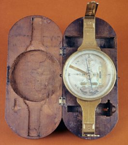
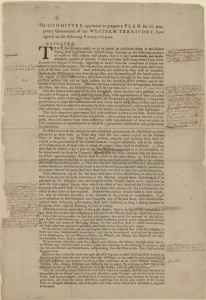
The committee’s answer was the Land Ordinance of 1784 which attempted to define and standardize surveying methods to create a grid of small plots of land across the territories. These surveyed squares could then be subdivided, numbered, and recorded for sale. In this manner, the landscape could be divided and sold to settlers unseen — that is, without the surveyor having to physically walk the entire area, mapping the land in the old system of metes and bounds (which used natural markers like trees and rivers to define property). This older system was time consuming, required the surveyor’s physical presence in a sometimes dangerous landscape, and often led to land disputes as natural markers were altered or disappeared. While the 1784 Ordinance did not become law, it did define the rectangular system and laid out the principles that would measure and divide the landscape into what it is today.

“Surveyor’s Compass” in Andrew G. Gardner, “How Did Washington Make His Millions?” Colonial Williamsburg Journal (Winter 2013) accessed http://www.history.org/foundation/journal/winter13/washington.cfm

On May 20, 1785, Congress passed the Land Ordinance of 1785, a revised version of the 1784 plan which further described the system and codified a detailed survey plan which used mathematics and standardized chains for measuring. The ordinance stated that surveying would begin on the Ohio River, at a point that shall be found to be due north from the termination of a line which has been run as the southern boundary of the state of Pennsylvania.” According to historian Matthew Dennis, this rectangular survey system allowed the leaders of the young government to apply  their “nationalistic, scientific, and engineering mentality in transforming the continental landscape of North America, reconceptualizing its space, subduing and organizing it, and distributing it to white yeoman farmers in the interest of national expansion, and, they believed, democracy.”

Committee of Congress. Draft Report of Northwest Ordinance, March 1784. Broadside with emendations by Thomas Jefferson. Thomas Jefferson Papers, Manuscript Division, Library of Congress.

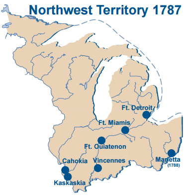
The removal of the native tribes living in the territories was the first step of the survey process.  Both the proposed 1784 Land Ordinance and the adopted 1785 Land Ordinance called for American Indian removal. The United States government worked towards this end through both military action, economic pressure, and treaties in order to make space for white male settlers to farm the land. On July 13, 1787, Congress passed the Northwest Ordinance, an act which created the Northwest Territory (an area that would become the states of Ohio, Indiana, Illinois, Michigan, Wisconsin, and part of Minnesota) and provided a system for settling the area to create new states.

Map of the Northwest Territory, Indiana Historical Bureau, “Indiana Territory,” The Indiana Historian (March 1999), 4, accessed in.gov/history.

The U.S. government viewed conflict with indigenous populations in the area as the greatest obstacle to the expansion and settlement of white Americans in the territory. According to historian Eric Hemenway of the Little Traverse Bay Bands of Odawa Indians:

Between 1774 and 1794, Indian villages in New York, Pennsylvania, Indiana and Ohio were constantly attacked by the American army and militias. The Shawnee, Delaware, Iroquois, Miami, Odawa, Wyandot and Mingo saw unspeakable violence committed against their villages during this time period. Over 100 Indian villages were burned and destroyed, leaving an unknown number of civilian casualties.

“Battle of Fallen Timbers,” engraving, 1846, in John Frost. Pictorial History of the United States, accessed http://ushistoryimages.com/sources.shtm#F

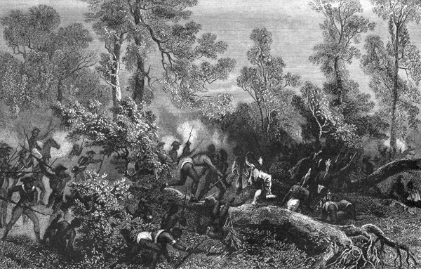
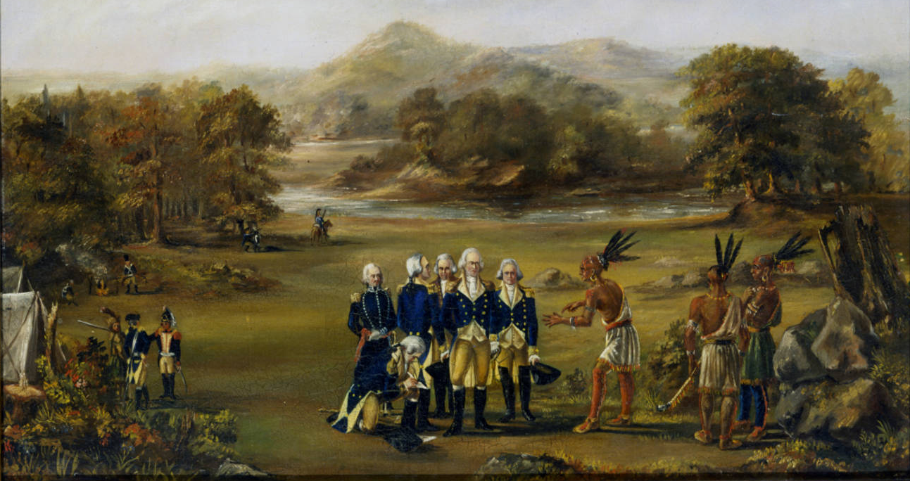
The U.S. government applied military, economic, and diplomatic pressure on native peoples to cede land and create a peace, no matter how tenuous. The military pressure was applied by President George Washington’s assignment of General Anthony Wayne to battle a confederacy led by Miami, Shawnee, and Lenape (Delaware) chiefs. After suffering major losses at the 1794 Battle of Fallen Timbers, many tribes living in the Northwest Territory were resigned to settling for peace. This resulted in the 1795 Treaty of Greenville, in which some tribal leaders ceded large sections of land in Ohio and Indiana to the United States and opened much of the area to white settlement. Many Wyandot, Delaware, Shawnee, Ottawa, Miami, Eel River, Wea, Chippewa, Potawatomi, Kickapoo, Piankashaw, and Kaskaskia lost large portions of their homeland. Still other native leaders resisted and contested this and subsequent treaties, and would later fight to regain their land under the leadership of Tecumseh and Tenskwatawa.

Detail of “Painting of Indian Treaty of Greenville,” oil on canvas, 1795, Chicago History Museum, accessed http://digitalcollection.chicagohistory.org/cdm/ref/collection/p16029coll3/id/1660

While the U.S. government offered payment in goods for signing the treaty, some Native Americans became dependent on these annuities as the land on which they made their living was taken from them. In some cases, they fell into debt and lost even more land as a result. This situation was often exploited by the United States government. For example, in 1803, President Thomas Jefferson wrote William Henry Harrison:

We shall push our trading houses, and be glad to see the good and influential individuals among [Great Lakes Indians] run in debt, because we observe that when these debts get beyond what the individuals can pay, they become willing to lop them off by a cession of lands.

After the Treaty of Greenville provided prospective colonists the security of peaceful settlement, Congress passed the Land Act of 1796. This legislation provided for the sale of land in the Northwest Territory. It reiterated that surveys would be conducted in areas “in which the titles of the Indian tribes have been extinguished.” It also appointed a Surveyor General directed to employ deputy surveyors.

Jared Mansfield, Essays, mathematical and physical : containing new theories and illustrations of some very important and difficult subjects of the sciences, New-Haven : Printed by William W. Morse, [1801], accessed HathiTrust.
General Rufus Putnam, a Revolutionary War veteran and an organizer of the Ohio Company, became the country’s first Surveyor General in 1796. Jefferson, however, became unhappy with Putnam’s irregular results and soon began to seek a more mathematically minded candidate who could factor in the curvature of the earth among other issues. Jared Mansfield (1759-1830) came to the attention of President Jefferson in 1801 upon the publication of his book Essays, Mathematical and Physical, one of the earliest works of original mathematics by an American. On May 21, 1803, Jefferson wrote to Mansfield, and conveyed his disappointment with Putnam for errors in “laying off the townships, not having been able to run parallel East & West Lines.” Jefferson expressed his confidence in Mansfield: “I am happy in possessing satisfactory proof of your being entirely master of this subject, and therefore in proposing to you to undertake the office.” Mansfield began his work as Surveyor General in the fall of 1803 as Congress and other U.S. government officials worked to open up the territories to settlement.

“Roger Woodfill, Greenville & Grouseland Treaty Lines,” accessed Virtual Museum of Surveying.

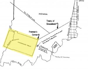
The land which would become Indiana was difficult to survey because much of it had yet to be acquired through treaty. The Vincennes Tract, an area ceded by local tribal authorities to French settlers in 1742, provided another unique obstacle. This area ran along the Wabash River and thus had been surveyed at an angle, and French settlers acquired titles to the land based upon this survey. Since 1787, the inhabitants of the Vincennes Tract regularly petitioned Congress to validate their titles. In May 1802, Congress determined that the territory should be surveyed by the rectangular method except where it had been previously surveyed. In other words, the Vincennes Tract would sit like an oddly angled puzzle piece within the rest of the rectangular pieces. The lines forming the rectangles would stop at the edge of the Vincennes Tract and then continue after it on all sides. According to survey historian Bill Hubbard, since the purpose of the rectangular survey was to organize the land for sale, there was no need to resurvey the tract.

Map of the Northwest Territory, Indiana Historical Bureau, “Indiana Territory,” The Indiana Historian (March 1999), 4, accessed in.gov/history.

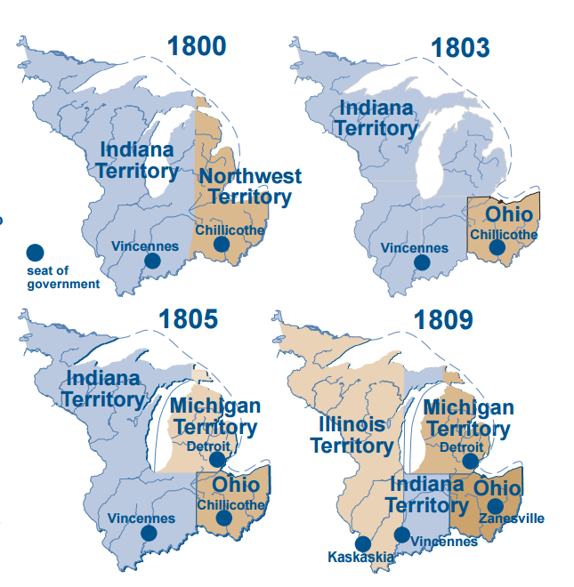
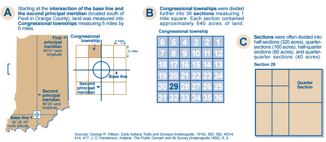
Meanwhile, in March 1803, Ohio attained statehood, which left the rest of the former Northwest Territory as the Indiana Territory. Congress wanted the Indiana Territory surveyed in full in preparation for American colonization. In June 1803, the Vincennes Tract’s boundaries were confirmed through Indian treaties and the edges surveyed. Surveying the Indiana Territory around the irregular tract became Mansfield’s first challenge as Surveyor General. U.S. government officials assumed it was a matter of time before the rest of the territory would be acquired from the Native Americans, and thus Mansfield needed to develop a technique for surveying this vast landscape that did not include the time-consuming and even dangerous physical trek through the entire landscape measuring with steps and chains. Instead, he determined that he could create a meridian and a baseline ran off the corners of the Vincennes Tract which would be the foundation of a grid made up of six-mile by six mile square plots of land called townships.

Mansfield planned a baseline that would start at the southwestern corner of the Vincennes Tract and run east-west to the edge of the territory and a meridian which ran from the southeastern edge of the tract north through the territory. The north-south line was called the Second Principal Meridian and coincides with 86° 28’ west longitude. The base line coincides with 38° 28’ 20” north latitude and became known locally as Buckingham’s Base Line. From the intersection of these lines, survey lines could be calculated every six miles in all four directions to create the grid of townships. Each township could then be further divided into one mile squares creating thirty-six sections of land. Each section contained 640 acres of land which could then be divided further in half, quarter, half-quarter, and quarter-quarter sections as needed. These plots would then be numbered and sold to settlers without the surveyor hiking the entire territory, the running of the two lines being the only physical surveying needed.

While Mansfield mathematically planned the baseline which would serve as a foundational line for the survey of the Indiana Territory, someone still had to mark the line into the landscape and take measurements. That task fell to a small crew led by deputy surveyor Ebenezer Buckingham, Jr., and he would long be remembered for his efforts. Originally from Connecticut, Buckingham migrated to Ohio in 1796 and began work as a farmhand for General Putnam. He assisted Putnum on survey trips in several Ohio counties, and in 1799, Putnam swore in Buckingham as a deputy surveyor.

Michael P. Conzen, The Making of the American Landscape (New York and London: Routledge, 2010), 143.

In 1804, Mansfield appointed Ebenezer Buckingham to lead a crew to run the base line. They began at a point on the south-side of the Vincennes Tract and ran a line east for 67.5 miles, marking off miles and half-miles on trees. Buckingham and crew then went to the southeast corner of the Vincennes Tract and ran a line due north until they reached the baseline. When they intersected the baseline, they marked the initial point. Then, they marked section corners and half-section corners until they reached the east end of the Vincennes Tract again. They packed up for the winter and returned the next season to finish extending the baseline east twelve miles and the meridian north in September 1805. The placement of the baseline and meridian in these locations allowed Buckingham and his crew to lay the foundations for the survey system and include the Vincennes Tract in it, all without encroaching on lands that still belonged to Native Americans. After this, the townships could be numbered and the land further divided. The township numbers would be increased east and west away from the Principal Meridian and be numbered away from the Baseline north and south, starting at the Initial Point where the two lines crossed.

“Abraham Lincoln, Congressman-elect from Illinois,” daguerreotype, circa 1846-7,Daguerreotype collection, ibrary of Congress Prints and Photographs Division, accessed https://www.loc.gov/resource/ppmsca.53842/

Because the rectangular survey clearly mapped the land, organized, and numbered it, settlers knew that any land they purchased had a secure title. This was not true in states not mapped in such a standardized way.  For example, in Kentucky, the same land was sometimes surveyed multiple times in different ways giving rise to title disputes. For example, in 1808, a carpenter and cabinet maker named Thomas Lincoln purchased a farm near Nolin Creek, Kentucky. The following year, in the cabin that Thomas built on his land, his son Abraham Lincoln was born. The family soon moved to another farm, along Knob Creek for which Thomas paid cash years later in 1815. However, the titles of both his farms were challenged by competing claimants. According to Abraham Lincoln biographer William E. Gienapp, because Thomas did not have the resources to fight a possibly extensive court battle, “he simply sold out at a loss and in December 1816 moved to Indiana, where the federal government had surveyed the land.” Thus, the survey system played no small role in bringing the studious young man who would become the sixteenth President of the United States to Indiana.

Survey Map (left)accessed Elkhart County Surveyor, http://elkcosurveyor.org/history/;
Aerial View of Indiana (right) accessed Indiana Public Media,

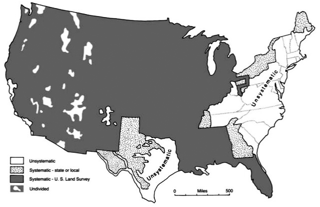
The legacy of the survey system still defines how Hoosiers interact with the landscape today and is seen in our counties, townships, and the quilted pattern of Indiana farmland. In fact, much of the country is organized by this system. According to historian Michael P. Conzen, “Except for the original 13 colonies, Texas, and some western mountainous areas, most of the country is parceled out on the township and range system.” The methods perfected by Mansfield and executed by men like Buckingham were applied throughout the vast landscape of the United States to the benefit of some and the anguish of others. In 2018, IHB will place a state historical marker for Buckingham’s Base Line in Dubois County at one point of the line, literally inserting the story of this complex landscape back into the landscape itself – a reminder that as Hoosiers we share both the legacy of those industrious settlers who arrived following a dream of a better life in a bright new democracy and the legacy of those native peoples who were harmed to make that dream a reality.

Photo from Miami Nation of Indiana, accessed http://www.miamiindians.org/

Special thanks to Annette Scherber who contributed research for this post.

Dr. Harvey “Old Borax” Wiley and His Poison Squad

hwwiley-02
Harvey Washington Wiley, M.D. Image courtesy of U.S. Food and Drug Administration.

For many people, the first thing that comes to mind when thinking of the early Pure Food movement is Upton Sinclair’s 1906 book The Jungle. However, Hoosier Harvey Wiley’s work in the field was already at its apex when Sinclair’s exposé was released. When Dr. Wiley started his career in the mid- to late-19th century, the production of processed foods in the US was on the rise due to the increasing number of urban dwellers unable to produce their own fresh food. With little to no federal regulation in this manufacturing, food adulteration was rampant. Dr. Wiley made it his mission prove the importance of food regulation. With the help of a group of men known as the Poison Squad, he did just that.

Harvey Washington Wiley was born on a small farmstead near Kent, Indiana on October 18, 1844. He attended Hanover College from 1863-1867, with the exception of a few months in 1864 when he served in Company I of 137th Indiana Volunteers during the Civil War. After graduating in 1867, Wiley moved to Indianapolis and began teaching at Butler University while earning his Ph.D. from the Medical College of Indiana. It was in 1874 that Dr. Wiley began his work as a chemist at Purdue University, where he developed an interest in adulterated food. Wiley argued that mass-produced food, as opposed to food produced locally in small quantities, contained harmful additives and preservatives and misled consumers about what they were actually eating. In the coming decades, Wiley would prove that this theory was correct and serve as one of the public faces of the pure food movement. As a 1917 advertisement in The (New York) Sun put it:

“Dr. Wiley it was who, at Washington, first roused the country to an appreciation of purity and wholesomeness in foods. He has been the one conspicuous figure in food betterment and food conservation in the present generation.”

In 1883, Wiley was appointed Chief Chemist of the Bureau of Chemistry, a division of the United States Department of Agriculture. While serving in this capacity, Wiley made the establishment of federal standards of food, beverages, and medication his priority. To this end, governmental testing of food, beverages, and ingredients began in 1902. The most famous of these tests were the “hygienic table trials,” better known by the name given to them by the media: “The Poison Squad.”

The Poison Squad
The “twelve young clerks, vigorous and voracious,” who made up the Poison Squad, sit six to a table. Image courtesy of U.S. Food and Drug Administration Flickr page.

During these trials, “twelve young clerks, vigorous and voracious” were fed and boarded in the basement of the Agricultural Department building in Washington D.C. Before each meal the men would strip and be weighed, any alteration in their condition being noted. At any one time, six of the group would be fed wholesome, unadulterated food. The other six were fed food laced with commonly used additives such as borax and formaldehyde. Every two weeks, the two groups would be switched. While the position of poison squad member may sound like it would be a hard one to fill, volunteers were lining up to participate in the tests, even writing letters such as the following to Dr. Wiley:

Image courtesy of U.S. Food and Drug Administration Flickr page.

The experiments commenced in November of 1902 and by Christmas, spirits among the Squad members were low. According to a Washington Post article from December 26,

“The borax diet is beginning to show its effect on Dr. Wiley’s government-fed boarders at the Bureau of Chemistry, and last night when the official weights were taken just before the Christmas dinner the six guests who are taking the chemical course showed a slight decrease in avoirdupois . . . To have lost flesh on Christmas Day, when probably everybody else in Washington gained more or less from feasting, was regarded by the boarders themselves as doubly significant.”

A look at the “unprinted and unofficial menu” from the Christmas meal, also printed in the Post, sheds some light on what may have given the boarders pause in their Christmas feasting.

Image courtesy of The Washington Post: Dec 26, 1902; ProQuest Historical Newspapers: The Washington Post pg. 2. 

Much of the information reported by the press during this time came from the members of the squad themselves, until “Old Borax” as Wiley came to be known, issued a gag-order in order to preserve the sanctity of the scientific studies happening. Despite the order, public interest had been peaked and tongues and pens wagged around the country. As one Columbia University scholar put it, “Supreme County justices could be heard jesting about the Squad in public, and even minstrel shows got in on the act.” There were even poems and songs written about the trials.

If ever you should visit the Smithsonian Institute,
Look out that Professor Wiley doesn’t make you a recruit.
He’s got a lot of fellows there that tell him how they feel,
They take a batch of poison every time they eat a meal.
For breakfast they get cyanide of liver, coffin shaped,
For dinner, undertaker’s pie, all trimmed with crepe;
For supper, arsenic fritters, fried in appetizing shade,
And late at night they get a prussic acid lemonade.

They may get over it, but they’ll never look the same.
That kind of a bill of fare would drive most men insane.
Next week he’ll give them moth balls,
a LA Newburgh, or else plain.
They may get over it, but they’ll never look the same.

-Lew Dockstade, “They’ll Never Look the Same”

At the close of the Borax trials in 1903, Wiley began cultivating relationships with some journalists, perhaps in hopes of turning the reports from jovial, and sometimes untrue, conjectures to something more closely resembling the serious work being done.

Along with borax and formaldehyde, the effects of salicylic acid, saccharin, sodium benzoate and copper salts were all studied during the Hygienic Table Trials. The reports generated during the Hygienic Table Trials and the media coverage that followed set the stage for the passage of the Pure Food and Drug Act of 1906, the same year in which the trials were concluded. According to the FDA, the Pure Food and Drug Act of 1906, also known as The Wiley Act, serves the purpose of “preventing the manufacture, sale, or transportation of adulterated or misbranded or poisonous or deleterious foods, drugs, medicines, and liquors, and for regulating traffic therein.”

By requiring companies to clearly indicate what their products contained and setting standards for the labeling and packaging of food and drugs, the Act helped consumers make informed decisions about products that could affect their health. While controversies over additives and government regulations continue to this day, Dr. Harvey Wiley and his Poison Squad played a major role in making the food on our tables safe to eat.

Check out our historical marker and corresponding review report to learn
more about Wiley.                            marker picLearn about the history of public health in Indiana and Wiley’s contributions with our publication The Indiana Historian.

Wendell Willkie: The Dark Horse

Wendell Willkie, circa 1941. Image courtesy of History.com.
Wendell Willkie, circa 1940. Image courtesy of History.com.

This blog post is an expanded version of Nicole Poletika’s original marker review essay, which can be viewed here.

The presidency of the United States is seen by many as the ultimate prize in American politics. It has been held by lawyers, philanthropists, and even actors. The State of Indiana has been at the center of presidential history, claiming Hoosier Presidents Benjamin Harrison and his grandfather, William Henry Harrison. However, one year sticks out more for what didn’t happen than what did: 1940.

That year, Hoosier natives Wendell Willkie and Paul V. McNutt, came very close to winning the presidency but ultimately lost, in their own ways, to Franklin Delano Roosevelt (FDR). This is the first of two blogs dedicated to the Indiana men who ran for the highest office in America.

Wendell Willkie's childhood home in Elwood, Indiana. Image courtesy of Indiana Memory.
Wendell Willkie’s childhood home in Elwood, Indiana. Image courtesy of Indiana Memory.
The IU Debate Team, 1916. Willkie is front row, center. Image courtesy of Indiana University, Bloomington.

Wendell Willkie, the 1940 Republican Candidate for President, was born in 1892 in Elwood, Indiana. Willkie attended Indiana University, where he became friends with another budding young student, Paul V. McNutt. When McNutt was the President of the Student Union, Willkie was the President of the Jackson Club, a Democratic leaning political group. Their paths continued to cross throughout the rest of their lives. Willkie received his law degree from Indiana University in 1916. In 1929, after practicing law in Akron, Ohio for the Firestone Tire Co, he provided legal counsel for The Commonwealth & Southern Corporation, a large public utilities company, of which he later became president.

As company president, he fought against FDR’s federally funded New Deal program to establish the Tennessee Valley Authority (TVA), which intended to provide employment to the many jobless during the Great Depression. Willkie opposed the TVA because it would directly compete with The Commonwealth & Southern Corporation and because he opposed both governmental and private monopolies. While Willkie lost, he gained notoriety as “the most articulate, vigorous spokesman for the business community.”

Willkie, as president of Commonwealth and Southerm, receives a check from TVA aministrator David E. Lilienthal for the purchase of the Tennessee Electric Power Company. Image courtesy of Indiana State Library.
Willkie, as president of Commonwealth and Southerm, receives a check from TVA administrator David E. Lilienthal for the purchase of the Tennessee Electric Power Company. Image courtesy of Indiana State Library.

After gaining the attention of Republican politicians with his outspoken belief in free enterprise, Willkie was nominated as the Republican presidential candidate to run against FDR in 1940 in what was described by the Indianapolis News as “one of the most dramatic events in American political history.” Despite never holding political office, much like modern Republican presidential candidate Donald Trump, Willkie was nominated after the sixth ballot was taken at the Republican National Convention. He defeated well-known political figures such as Governor Thomas E. Dewey and Senator Robert A. Taft. It was here that he earned the campaign moniker of “Dark Horse,” since his candidacy was such a political upset. Republicans sought a fresh candidate to represent the party as World War II intensified abroad and Americans became more determined than ever to avoid war at home.

Around this same time, his IU colleague and friend Paul McNutt, dropped out of consideration for the Democratic nomination, giving in to Roosevelt’s desire for an unprecedented third term. Had McNutt been nominated, both major party candidates for President would have been from the State of Indiana.

The official notification ceremony of the Republican presidential nomination for Wendell Willkie, Elwood, Indiana, August 17, 1940. Image courtesy of the Library of Congress.
Wendell Willkie at the notification ceremony for his presidential nomination, Elwood, Indiana, 1940. Image courtesy of Indiana Memory.
"Wings for Willkie" campaign button, circa 1940s. Image courtesy of Indiana Historical Society.
“Wings for Willkie” campaign button, circa 1940s. Image courtesy of Indiana Historical Society.

Despite a well-fought campaign, Willkie lost the election to Roosevelt in a landslide, earning only 82 electoral votes to Roosevelt’s 449. He also lost the popular vote by nearly five million. Many commentators thought that his progressive position on civil rights and support of liberal internationalism alienated him from his party. Voters also struggled to identify his position on major causes because he covered a wide range of issues briefly.

Lard sculptures of Franklin Roosevelt and Wendell Willkie in the Agriculture and Horticulture Building at the 1940 Indiana State Fair. Image courtesy of Indiana Historical Society.

Even though he lost the presidential election in 1940, Willkie and FDR became friends and political allies, as they held similar views on foreign policy and civil rights. In particular, Willkie, both during and after the campaign, went against many in his party with his support of FDR’s policy to dispatch war aid to Britain in 1940, as opposed to fighting abroad or remaining isolated from the war. Historian Justin H. Libby describes Willkie’s support of war aid as the “forerunner of the bipartisan policy.”

Willkie’s support for aid eventually gained favor among the general public, allowing FDR to pass the Lend-Lease Bill in 1941, which postponed U.S. involvement in the war. He also served the President by traveling the globe as a U.S. emissary to observe the war abroad and meet with foreign leaders, reporting on his experiences. As an internationalist, Willkie worked for “world peace,” presenting a bipartisan resolution to the Republican National Committee in 1942 that was eventually passed.

African American veteran Isaac Woodard at the Wendell Willkie memorial building in New York, circa 1946. Image courtesy of the Library of Congress.

On the home front, Willkie avidly defended the rights of African Americans and publicly advocated for the improved housing, education and health of black citizens. He was widely concerned with the treatment of African Americans in the Armed Forces, arguing in various articles that they should be afforded the same freedom at home that they fought for abroad.

In his 1944 article “Citizens of Negro Blood” for Collier’s Magazine, Willkie stated that World War II “has made us conscious of the contradictions between our treatment of our Negro minority and the ideals for which we are fighting. The equitable treatment of racial minorities in America is basic to our chance for a just and lasting peace.” He appealed to political figures to strengthen anti-lynching measures and to eliminate state poll taxes that often prevented African Americans from voting. Willkie ultimately brought attention to the struggles of all minority citizens, arguing in the New York Times that they were “rich assets of democracy.”

One World by Wendell Willkie. Image courtesy of Doerbooks.com.
One World by Wendell Willkie. Image courtesy of Doerrbooks.com.

In 1943, Willkie wrote about his experiences traveling the globe in his best-selling book One World. He described his trip, in which he traveled with Army and Navy officials to over half a dozen countries. His observations, made during a period before the United States frequently worked and communicated with other countries, has been described as “extraordinarily perceptive and statesmanlike.” It spent four months on the New York Times bestseller list and was an influential text on the future United Nations.

Willkie sought the Republican presidential nomination in 1944, but dropped out of the race in April after a poor showing in the Wisconsin primaries. Constant comparisons to FDR, his liberal stance on civic and international issues, and general independence from other Republican members resulted in the loss of party support.

Wendell Willkie memorial at the Indiana State Capitol. Image courtesy of Wiki Commons.

Willkie died October 8, 1944 and was buried in East Hill Cemetery in Rushville, Indiana. President Roosevelt issued a statement honoring Willkie as “one of the great men of our time.” In addition to the memorial erected at his gravesite, memorials to Willkie were dedicated in Elwood and in the State House Rotunda in Indianapolis. The Willkie Memorial Building, created to serve as a center for the Freedom House and other causes he supported, was dedicated in New York on the first anniversary of his death. Willkie, with the support of Eleanor Roosevelt, helped established Freedom House in 1941 as an organization that could “strengthen human rights and civil liberties in the United States.” As of 2016, the Freedom House still advocates for human rights.

Wendell Willkie’s ambitions for the White House never materialized, but his influence on American politics can still be felt, especially in his stances on international relations, civil rights, business, and foreign policy. His friendship and support of Franklin Roosevelt, even after losing to him, benefited the country during wartime. Willkie was a results man; he believed deeply in the power of institutions and people to get the job done right, whether in politics or in business. His bipartisanship and amiable demeanor earned him respect from leaders all across the country. In the end, the “Dark Horse” became a statesman on par with almost any President.

Jasper Sherman Bilby: To Map the Earth, Part II

Part one, covering Bilby’s early life and years working for the US Coast and Geodetic Survey, can be read here.

———————————————————-

A Bilby Steel Tower, 110 ft. high in the San Joaquin Valley, California. Photograph by Floyd Risvold. Courtesy of NOAA.

Jasper Sherman Bilby’s time in the US Coast and Geodetic Survey (US C&GS) is best remembered for his invention, the Bilby Steel Tower. The tower revolutionized the Survey’s procedures, costs, and efficiency. As described by historian John Noble Wilford, the Bilby Tower was used for horizontal-control surveys (measuring latitude and longitude) and allowed surveyors to see over hills, trees, and other impediments to make their measurements more accurate.

In his manual, Bilby Steel Tower for Triangulation, Bilby detailed this problem of visibility:

In many regions it is not possible to select stations for a scheme of triangulation and have the stations intervisible from the ground, as trees, buildings, and other objects obstruct the line of vision between adjacent points. On geodetic surveys, covering wide expanses of territory, the curvature of the earth must also be taken into account. Towers are, therefore, necessary to elevate above intervening obstructions the observer and his instrument at one station and the signal lamp or object on which he makes his observations at the distant station.

According to US C&GS documents on his field assignments, Bilby began his designs on the tower as early as December 1926. He then took his early design plans to the Aeromotor Factory in Chicago to make a prototype. Once the prototype proved successful, twelve complete towers were manufactured by the same company and were first tested on assignment in Albert Lee, Minnesota with positive results.

A schematic drawing of the Bilby Steel Tower. Courtesy of NOAA.

In terms of design, the Bilby Tower was actually comprised of two independent towers. An inner tower carried the intricate instruments for survey calculations and the outer tower supported the surveyors who made the measurements. These towers never connected, so that the vibrations of either one did not disturb the survey calculations. In 1927, it was named the “Bilby Steel Tower” by Colonel Lester E. Jones, then director of the US C&GS.

In a 1927 commendation letter, Secretary of Commerce (and future President) Herbert Hoover commended Bilby’s invention for its cost and time efficiency and cited the surveyor’s service as essential to the United States government.

I have just learned, upon my return to Washington, of the excellent results which the Coast and Geodetic Survey is getting in its triangulation from the steel towers which you designed.

The accelerated progress of the work, accompanied by a reduction in its cost, is highly gratifying to me and justify the commendation which this letter conveys.

However, Hoover’s letter was not the only special commendations he received while in the US C&GS. He earned financial promotions through 1915- 1916 and in 1930, the position of “Chief Signalman” was created for him. Understanding Bilby’s work as essential to the US C&GS, President Hoover used an executive order in 1932 to waive the mandatory federal retirement age.

Letter from Secretary of Commerce Herbert Hoover to Jasper Sherman Bilby. Hoover commends Bilby for his invention of the Bilby Steel Tower. Courtesy of Surveyors Historical Society Collection.

Within the first ten years of use, the Bilby Steel Tower saved the federal government $3,072,000, according to the itemized cost listing of both wooden and steel towers from 1927-1937 by the US C&GS field assignment reports. The 1928 US C&GS annual report explained how the implementation of Bilby Towers cut unit costs down by nearly half, much more than the projected 25-35% savings. It also increased their surveying progress to over “150 miles per month.”

Within a few years of its invention, the Bilby Steel Tower was used in nations such as France, Australia, Belgium, and Denmark. In particular, Major M. Hotine, Royal Engineer of the Ordinance Survey Office in Southampton, England, wrote of his satisfaction with the Bilby Steel Tower in the December 1938 issue of the US C&GS Field Engineers Bulletin:

We have just completed among other work this season, the primary observation for our new triangulation in the Eastern Counties of England. The country here is so flat and enclosed that we had to use Bilby Steel Towers at 34 of the main Stations [sic], to say nothing of several secondary stations surrounding such Steel Tower States, we thought it would be advisable to observe at the same time as the primary work. You may be interested to know that these admirable Steel Towers were entirely satisfactory; and that we were very deeply impressed with the conception, design, and construction of these Towers.

Along his invention, he wrote several government manuals on the theory and practice of geodetic surveying. His most famous and influential work was the manual on his invention, the Bilby Steel Tower. Bilby Steel Tower for Triangulation (1929) covered every aspect of his invention, from concept and construction to its usage and transport. It stayed in publication through two editions. Other manuals include Precise Traverse and Triangulation in Indiana (1922), Reconnaissance and Signal Building (1923), and Signal Building (1943).

Jasper Sherman (right) with his son and fellow surveyor Walter J. Bilby (left), circa 1926. Courtesy of Surveyor's Historical Society Collection.
Jasper Sherman (right) with his son and fellow surveyor Walter J. Bilby (left), circa 1926. Courtesy of Surveyor’s Historical Society Collection.

Bilby retired from the US C&GS in 1937. His final assignment was at a triangulation station in Hunt City, Jasper County, Illinois, completing his 53 year career exactly where it began on the 39th parallel. His 1927 manual for the Bilby Tower was revised for surveyors in 1940 and his work continued to influence the trade well into the 1980s. The last Bilby Tower was erected in 1984, in Connecticut. A complete survey tower, originally constructed on an island south of New Orleans, Louisiana called Couba in 1972, was restored and moved to the town park in Bilby’s hometown of Osgood, Ripley County, Indiana in 2014.

Bilby died on July 18, 1949 in Batesville, Indiana. He was buried in Washington Park Cemetery in Indianapolis. His long career and advancements in geodetic surveying technology, particularly on the 39th parallel, ensured the completion and accuracy of the National Spatial Reference System (NSRP), a first-order triangulation network of the United States.

The NSRP, according to the National Geodetic Survey, is a “consistent coordinate system that defines latitude, longitude, height, scale, gravity, and orientation throughout the United States.” This system’s continued use ensures accurate information for the United State’s Global Navigation Satellite System (GNSS), known domestically as the Global Positioning System (GPS).

The National Spatial Reference System. Bilby's work on the 39th Parallel laid the groundwork for the completion of this system. Today, it informs our GPS technologies. Courtesy of NOAA.
The National Spatial Reference System. Bilby’s work on the 39th Parallel laid the groundwork for the completion of this network of survey points. Today, it informs the US’s GPS technologies. Courtesy of NOAA.

Jasper Sherman Bilby’s innovation and inventiveness left an indelible mark on surveying in the United States and the world. His Bilby Steel Tower, and the knowledge it advanced, revolutionized mapmaking for generations.

In short, Bilby helped us map the earth.

Ambrose Bierce: The Evanescent Man

Ambrose Bierce by J.H.E. Partington. Courtesy of Library of Congress.

The history of American letters overflows with stories of eccentric characters, both from the pages and their authors. One particular author whose unique view of the world shaped his writings and his lifestyle was Hoosier Ambrose Bierce. Like Mark Twain, Bierce is usually associated with the San Francisco writing scene of the late-19th century. However, he spent many of his formative years in Indiana, learning about the newspaper business and ultimately enlisting in the Civil War. These early experiences not only shaped his incomparable writing style, but they influenced his distinctive views about life and religion.

Ambrose Gwinnett Bierce was born June 24, 1842 in Horse Cave Creek, Ohio. Bierce’s early life, after he and his family moved to Indiana, remains shrouded in mystery. Some sources indicate that the Bierce family moved to Kosciusko County in 1846, but it is hard to verify. Bierce reportedly lived on the family’s settlement in Walnut Creek until he was 15, when he moved to Warsaw to work as a “printer’s devil” (an apprentice tasked with multiple duties) for the Republican newspaper, the Northern Indianan. Reportedly, Bierce also traveled to Kentucky in 1859-60, learning typography at the Kentucky Military Institute.

After returning from Kentucky, Bierce reportedly lived in Elkhart from 1860-1861. At the outbreak of the Civil War, Bierce enlisted in Company C of the Ninth Indiana Regiment in April 1861 and served as a private for three months. He was promoted to Sergeant in July 1861, when he reenlisted for a three year term. His upgrade in rank came as a result of his valor during the Battle of Laurel Hill on July 10, 1861. He was wounded at Kennesaw Mountain in 1864 and eventually opted not to reenlist, mustering out in January 1865 with the rank of First Lieutenant. Bierce’s intense and often painful experiences during his service in the Civil War inspired much of his literary work, particularly his short fiction and journalism.

Company A, 9th Indiana Infantry. Photograph by Matthew Brady. Courtesy of U .S. National Records and Archives Administration.
Company A, 9th Indiana Infantry. Photograph by Matthew Brady. Courtesy of U .S. National Archives and Records Administration.

Bierce began his journalism career in 1867, writing poems and essays for the Californian and Golden Era, under newspaper editor James T. Watkins. From 1868-1872, Bierce wrote a local column for the San Francisco News Letter called the “Town Crier.” One critic referred to his writing as “humor [that] borders as nearly upon the blasphemous and sacrilegious as that of Swift or Sterne.” Another review considered his early works, “The Haunted Valley” and “Broke,” as offbeat pieces that showed his “capacity, acute observation, and descriptive powers of very unusual simplicity, grace, and effectiveness.”

For the next three years, Bierce lived and worked in England, under the pseudonym “Dod Grile.” The origins of his unorthodox pen name came from an 1872 letter, written by a friend and early employer of Bierce in England named Tom Hood, who addressed Bierce as “Dear God Rile.” Bierce used an anagram of it, “Dod Grile,” as a pen name while in England. As biographer Roy Morris speculates, Bierce may have chosen this simple name as a way to attract readers, same as Samuel Clemens did with “Mark Twain.”

Bierce’s columns appeared in English and American newspapers. Bierce also published three collected humor works while in Great Britain; his most successful was Cobwebs from an Empty Skull, published in 1873. Prominent advertisements and reviews in This Week’s News and Lloyd’s Weekly London Newspaper solidified their modest success.

A lithograph of the devil from Cobwebs from an Empty Skull. Courtesy of Internet Archive.

After his time in England, Bierce returned to California and began work at the Argonaut and the Wasp and established his successful column, “Prattle.”  This column gave Bierce a platform to express his views on politics, current events, literature, and history, often with a humorous slant. As an example, this short quip about a millionaire’s dining habits appeared in the March 13, 1886 issue of the Wasp:

There is a man in San Francisco—a millionaire who has revived a very ancient custom, I am told. This gentleman is rather fond of dining people at his house—mostly men. Between the courses, now and then during the meal, he introduces various uncouth monsters, whose antics are supposed to amuse and edify the guests. I am told they don’t. A friend of mine has asked me to complain of the infliction—which I willingly do, although it is not the simplest method of relief that my friend could have thought out. If he does not relish monsters with his dinner why does he not dine at home and ask to have the monsters sent over to him afterward, as a separate entertainment?

By 1898, Bierce renamed his column “War Topics” and wrote mostly of his early support and subsequent ambivalence regarding the Spanish-American War.

In 1887, he worked for newspaper magnate William Randolph Hearst at the San Francisco Examiner. Like in Britain, Bierce’s columns were nationally syndicated, in outlets like the Wichita Eagle, The Louisiana Democrat, and the Washington Herald. Even though Hearst gave Bierce nearly complete editorial freedom, a growing antagonism existed between them. This may have been due to Bierce’s disgust with some of Hearst’s other journalists, specifically after 1906. Bierce formally left the employ of Hearst in March of 1909 to focus on compiling his collected works and memoirs.

In 1891, he compiled many of his Civil War tales into Tales of Soldiers and Civilians.  The book included “An Occurrence at Owl Creek Bridge,” which Hoosier satirist Kurt Vonnegut called the “greatest American Short Story.”  The widely anthologized tale excellently displays Bierce’s style and grasp of the complexities of war.  Film maker Robert Enrico adapted the story into an Academy Award winning short film (1963), which Rod Serling subsequently used as a Twilight Zone episode.

In this excerpt from “An Occurrence at Owl Creek Bridge,” Bierce reflects on death in war:

Death is a dignitary who, when he comes announced, is to be received with formal manifestations of respect, even by those most familiar with him. In the code of military etiquette silence and fixity are forms of deference.

 Many reviewers praised the Tales of Soldiers and Civilians after its publication. A New York Tribune reviewer noted, Bierce’s stories are “elaborated pictures of what the American soldier actually experienced in the great war [Civil War].” New Orleans’ Daily Picayune called Bierce a “genius” and considered the anthology the “most noteworthy book of stories by an American writer published in ten years.”

Title page of Tales of Soldiers and Civilians. Courtesy of Internet Archive.

It is somewhat fitting that an author known for his unexpected plot twists would have a surprise coda to his own life.  Bierce’s mysterious disappearance in 1914 proved to be as complicated as his early years in Indiana. After his last letters to family and friends in 1913, there is only one primary source (a letter to a friend) that suggests that he went to Mexico. The other indication that he was headed that way is in letters from the fall and winter of 1913, where he repeatedly describes his future trip to Mexico. His final letter to a family member, dated November 6, 1913, notes that “I shall not be here long enough to hear from you, and don’t know where I shall be next. Guess it doesn’t matter much.” However, a letter from December 26, 1913 to friend Blanche Partington places him in Chihuahua, Mexico but the last sentence of the letter leaves it more ambiguous: “As to me, I leave here tomorrow for an unknown destination.”

Based on the evidence of this last letter, Bierce possibly went to Mexico, but as investigator Joe Nickell notes, this supposed last letter attributed to Bierce, and preserved by his daughter, is probable at best. Therefore, it is more likely that he disappeared after 1914 and that the claim that he went to Mexico is plausible but not confirmed, based on his letters from late 1913. Bierce’s “death” was as elusive as the man himself.

An Occurrence at Owl Creek Bridge and Other Stories by Ambrose Bierce is available at the Indiana Historical Bureau book shop.

Visit Part Two to learn about Bierce’s connection to 19th-century freethought.