Jasper Sherman Bilby: To Map the Earth, Part II

Part one, covering Bilby’s early life and years working for the US Coast and Geodetic Survey, can be read here.

———————————————————-

A Bilby Steel Tower, 110 ft. high in the San Joaquin Valley, California. Photograph by Floyd Risvold. Courtesy of NOAA.

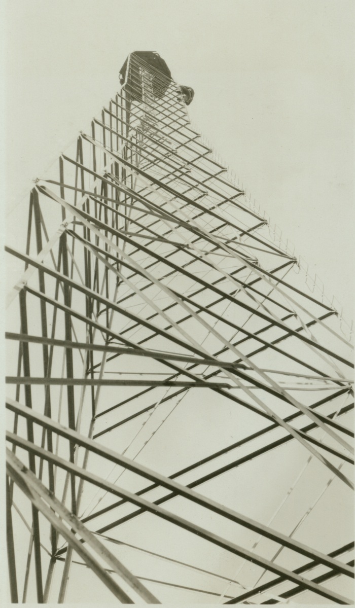
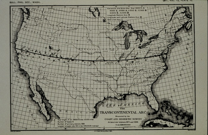
Jasper Sherman Bilby’s time in the US Coast and Geodetic Survey (US C&GS) is best remembered for his invention, the Bilby Steel Tower. The tower revolutionized the Survey’s procedures, costs, and efficiency. As described by historian John Noble Wilford, the Bilby Tower was used for horizontal-control surveys (measuring latitude and longitude) and allowed surveyors to see over hills, trees, and other impediments to make their measurements more accurate.

In his manual, Bilby Steel Tower for Triangulation, Bilby detailed this problem of visibility:

In many regions it is not possible to select stations for a scheme of triangulation and have the stations intervisible from the ground, as trees, buildings, and other objects obstruct the line of vision between adjacent points. On geodetic surveys, covering wide expanses of territory, the curvature of the earth must also be taken into account. Towers are, therefore, necessary to elevate above intervening obstructions the observer and his instrument at one station and the signal lamp or object on which he makes his observations at the distant station.

According to US C&GS documents on his field assignments, Bilby began his designs on the tower as early as December 1926. He then took his early design plans to the Aeromotor Factory in Chicago to make a prototype. Once the prototype proved successful, twelve complete towers were manufactured by the same company and were first tested on assignment in Albert Lee, Minnesota with positive results.

A schematic drawing of the Bilby Steel Tower. Courtesy of NOAA.

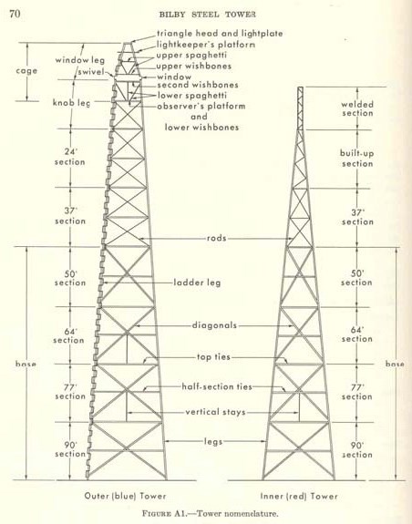
In terms of design, the Bilby Tower was actually comprised of two independent towers. An inner tower carried the intricate instruments for survey calculations and the outer tower supported the surveyors who made the measurements. These towers never connected, so that the vibrations of either one did not disturb the survey calculations. In 1927, it was named the “Bilby Steel Tower” by Colonel Lester E. Jones, then director of the US C&GS.

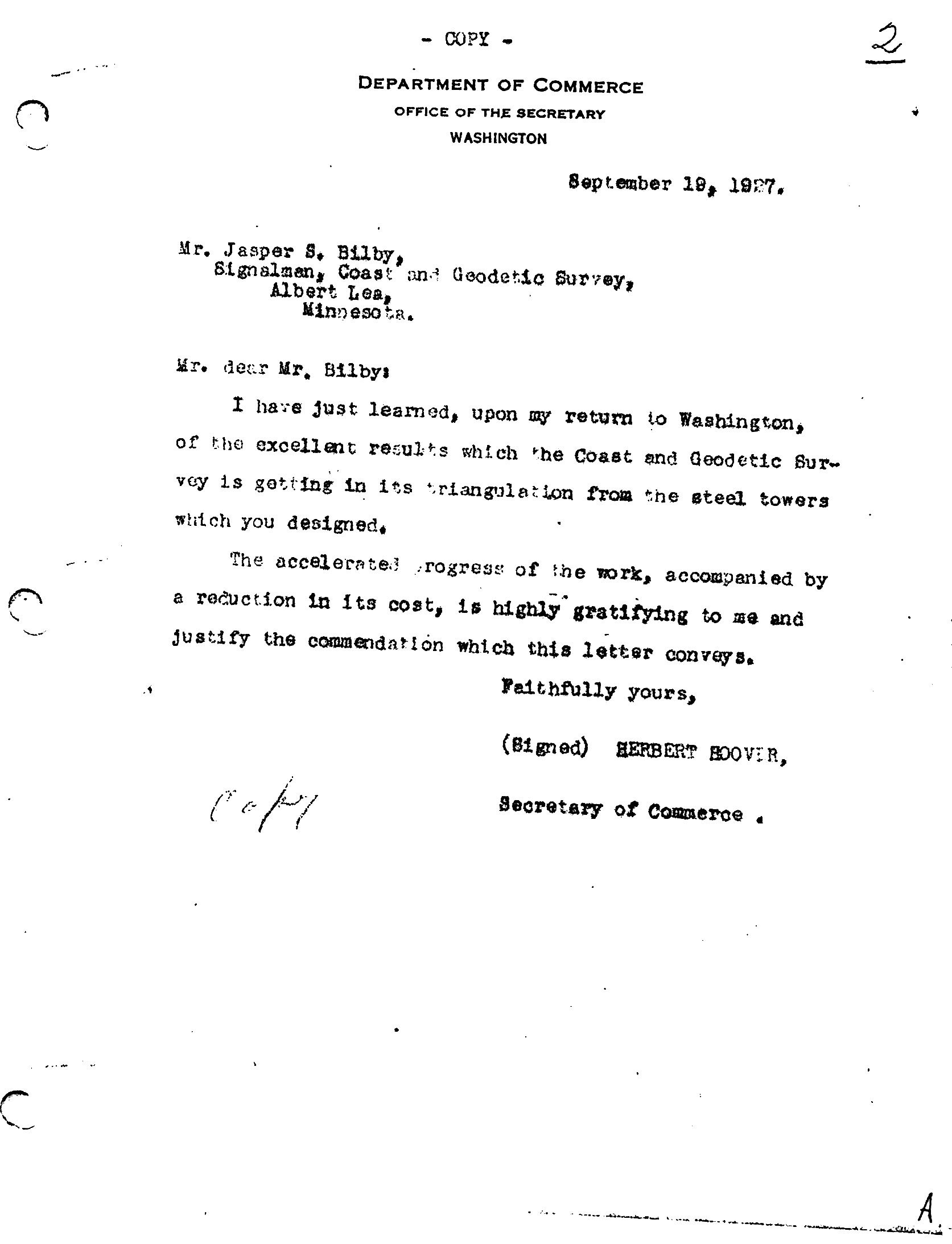
In a 1927 commendation letter, Secretary of Commerce (and future President) Herbert Hoover commended Bilby’s invention for its cost and time efficiency and cited the surveyor’s service as essential to the United States government.

I have just learned, upon my return to Washington, of the excellent results which the Coast and Geodetic Survey is getting in its triangulation from the steel towers which you designed.

The accelerated progress of the work, accompanied by a reduction in its cost, is highly gratifying to me and justify the commendation which this letter conveys.

However, Hoover’s letter was not the only special commendations he received while in the US C&GS. He earned financial promotions through 1915- 1916 and in 1930, the position of “Chief Signalman” was created for him. Understanding Bilby’s work as essential to the US C&GS, President Hoover used an executive order in 1932 to waive the mandatory federal retirement age.

Letter from Secretary of Commerce Herbert Hoover to Jasper Sherman Bilby. Hoover commends Bilby for his invention of the Bilby Steel Tower. Courtesy of Surveyors Historical Society Collection.

Within the first ten years of use, the Bilby Steel Tower saved the federal government $3,072,000, according to the itemized cost listing of both wooden and steel towers from 1927-1937 by the US C&GS field assignment reports. The 1928 US C&GS annual report explained how the implementation of Bilby Towers cut unit costs down by nearly half, much more than the projected 25-35% savings. It also increased their surveying progress to over “150 miles per month.”

Within a few years of its invention, the Bilby Steel Tower was used in nations such as France, Australia, Belgium, and Denmark. In particular, Major M. Hotine, Royal Engineer of the Ordinance Survey Office in Southampton, England, wrote of his satisfaction with the Bilby Steel Tower in the December 1938 issue of the US C&GS Field Engineers Bulletin:

We have just completed among other work this season, the primary observation for our new triangulation in the Eastern Counties of England. The country here is so flat and enclosed that we had to use Bilby Steel Towers at 34 of the main Stations [sic], to say nothing of several secondary stations surrounding such Steel Tower States, we thought it would be advisable to observe at the same time as the primary work. You may be interested to know that these admirable Steel Towers were entirely satisfactory; and that we were very deeply impressed with the conception, design, and construction of these Towers.

Along his invention, he wrote several government manuals on the theory and practice of geodetic surveying. His most famous and influential work was the manual on his invention, the Bilby Steel Tower. Bilby Steel Tower for Triangulation (1929) covered every aspect of his invention, from concept and construction to its usage and transport. It stayed in publication through two editions. Other manuals include Precise Traverse and Triangulation in Indiana (1922), Reconnaissance and Signal Building (1923), and Signal Building (1943).

Jasper Sherman (right) with his son and fellow surveyor Walter J. Bilby (left), circa 1926. Courtesy of Surveyor's Historical Society Collection.
Jasper Sherman (right) with his son and fellow surveyor Walter J. Bilby (left), circa 1926. Courtesy of Surveyor’s Historical Society Collection.

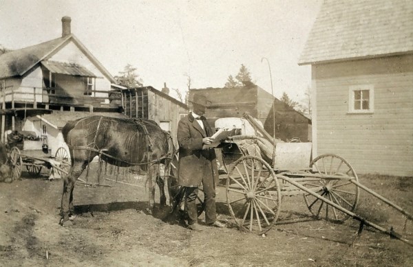
Bilby retired from the US C&GS in 1937. His final assignment was at a triangulation station in Hunt City, Jasper County, Illinois, completing his 53 year career exactly where it began on the 39th parallel. His 1927 manual for the Bilby Tower was revised for surveyors in 1940 and his work continued to influence the trade well into the 1980s. The last Bilby Tower was erected in 1984, in Connecticut. A complete survey tower, originally constructed on an island south of New Orleans, Louisiana called Couba in 1972, was restored and moved to the town park in Bilby’s hometown of Osgood, Ripley County, Indiana in 2014.

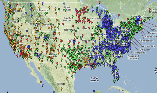
Bilby died on July 18, 1949 in Batesville, Indiana. He was buried in Washington Park Cemetery in Indianapolis. His long career and advancements in geodetic surveying technology, particularly on the 39th parallel, ensured the completion and accuracy of the National Spatial Reference System (NSRP), a first-order triangulation network of the United States.

The NSRP, according to the National Geodetic Survey, is a “consistent coordinate system that defines latitude, longitude, height, scale, gravity, and orientation throughout the United States.” This system’s continued use ensures accurate information for the United State’s Global Navigation Satellite System (GNSS), known domestically as the Global Positioning System (GPS).

The National Spatial Reference System. Bilby's work on the 39th Parallel laid the groundwork for the completion of this system. Today, it informs our GPS technologies. Courtesy of NOAA.
The National Spatial Reference System. Bilby’s work on the 39th Parallel laid the groundwork for the completion of this network of survey points. Today, it informs the US’s GPS technologies. Courtesy of NOAA.

Jasper Sherman Bilby’s innovation and inventiveness left an indelible mark on surveying in the United States and the world. His Bilby Steel Tower, and the knowledge it advanced, revolutionized mapmaking for generations.

In short, Bilby helped us map the earth.

Jasper Sherman Bilby: To Map the Earth, Part I

Surveyor Jasper Sherman Bilby on assignement in Minnesota, 1903. Courtesy of NOAA.
Surveyor Jasper Sherman Bilby on assignment in Minnesota, 1903. Courtesy of NOAA.

Indiana’s history is rich with inventors and pioneers. Philo T. Farnsworth, who lived in Fort Wayne for over a decade, invented the television and designed an early model of a fusion reactor. Elwood Haynes, Kokomo native and scientific prodigy, designed and assembled one of the first horseless carriages in the United States. Another Hoosier whose scientific mind for innovation proved indispensable to the nation was Jasper Sherman Bilby. His steel surveying tower radically reshaped the accuracy of map making and left a permanent mark on the way we view the United States.

Jasper Sherman Bilby (known as “J.S.”) was born in Rush County, Indiana on July 16, 1864 to Jasper N. Bilby and Margaret E. (Hazard) Bilby. Bilby’s early life has a rather tragic side; his father committed suicide in 1877 after being arrested for the sexual assault of one of his daughters. This hardship forced Bilby to leave school and to work on the family farm for a number of years in Fayette County to support his widowed mother.  After his marriage to Luella Cox in 1891, Bilby moved to Ripley County as early as 1893, according to Ripley County deed index books.

Plat book image of the Bilby Homestead, 1921. Coutesy of Ball State University.
Plat book image of the Bilby Homestead near Osgood, Ripley County, 1921. Courtesy of Ball State University.

Bilby joined the United States Coast & Geodetic Survey in September of 1884. Congress established this agency, originally called the United States Survey of the Coast, on February 10, 1807. Initially under the purview of the Treasury Department, the survey was reorganized under the US Department of Commerce in 1878 and renamed the United States Coast & Geodetic Survey (US C&GS). Today, it is under the umbrella of the National Oceanic and Atmospheric Administration (NOAA) and called the National Geodetic Survey (NGS).

Geodetic surveying is the geographical analysis of an area of land or bodies of water, accounting for the shape and curvature of the Earth. According to the NGS official website, the National Geodetic Survey, from its inception in 1807, has ensured accurate data for government and commercial purposes, such as “mapping and charting, navigation, flood risk determination, transportation, [and] land use and ecosystem management.” Additionally, the National Geodetic Survey’s work provides “authoritative spatial data, models, and tools [that] are vital for the protection and management of natural and manmade resources and support the economic prosperity and environmental health of the Nation.”

Bilby conducted his first survey work in Illinois along the 39th parallel. According to surveyor Raymond Stanton Patton, the 39th parallel was a line of latitude that spanned from Cape May, New Jersey to Point Area, California, and was the “first great piece of geodetic work accomplished by the Survey….”  His official position within the US C&GS for most of his career was that of “signalman.” A signalman uses flags or signal lights to indicate points within a geometric calculation between two survey points, usually between a point on shore and a point within a body of water. This practice ensures that those making the calculations on shore accurately represent the point in water.

A map of the 39th Parallel Arc. According to NOAA, it served as the "first great geodetic arc in the western hemisphere ." Courtesy of NOAA.
A map of the 39th parallel arc. According to NOAA, it served as the “first great geodetic arc in the western hemisphere .” Courtesy of NOAA.

Bilby traveled 511,400 miles during his 53 years in the US C&GS, from Illinois to California, according to his career field reports. Newspapers throughout the country recorded his cross-country traveling for the US C&GS, notably his work in states like Louisiana and Texas. Department of Commerce publications also chronicle his time in Wisconsin, Illinois, and Georgia, detailing his work in specific counties. In 1920, Bilby and his team surveyed the majority of Wisconsin and Illinois, providing exact coordinates for most regions adjacent to water. In these surveys, Bilby used the Traverse method of surveying, which is less accurate but quicker to calculate than Triangulation. (The traverse method uses pointed lines for measurements while triangulation uses angular measurements based on triangles.) Bilby and his team completed surveys within the Rio Grande valley in 1917, specifically from Harlington to Dryden. His efforts in the eastern area of the Rio Grande ensured more accurate measurements, adding to the US C&GS’s triangulation of the American west.

A 1926 article published in Popular Mechanics provides some of Bilby’s own words about his job, especially its difficulty before his invention and some personal stories. One of Bilby’s tasks within the US C&GS was reconnaissance, which is the practice of marking triangulation stations before the main survey party arrives. This cuts down on their work and ensures accuracy in their measurements. He told the magazine about the harsh weather and loneliness that often accompanies a surveyor’s life:

Especially…when the wind is howling through the trees, and the rain is pattering down on the tent, and you know there’s little change of anyone dropping by.

An artistic depiction of a wooden survey tower, in the July 1926 issue of Popular Mechanics. Courtesy of Google Books.

Nevertheless, he enjoyed his work and appreciated how radio was improving the public’s knowledge of the work of the US C&GS. Bilby notes:

Radio has made the coast and geodetic survey known more than it used to be. A few years ago people were always asking what the name meant, but now I often find they know us pretty well, from talks they’ve heard on the air. One lecture on mountain building which was broadcast from Washington was the means of getting me a fine dinner. I had stopped at a farmhouse to make inquiries and the farmer noticed my ‘geodetic’ tag. He mentioned this talk he’d heard, and when I said it must have been given by the chief of my division, Major Bowie, he became so interested that he made me stay to dinner and answer his questions. However, that wasn’t unwelcome after eating my own cooking for so long.

This story was published a year before the first usage of the Bilby Steel Tower, when wooden towers were still standard equipment.

His early years as a geodetic surveyor, particularly his negative experiences with wooden survey towers, would influence his greatest contribution to the field: the invention of the Bilby Steel Tower.

———————————————————-

Bilby’s influential invention, the Bilby Steel Tower, will be covered in Part II.

Ambrose Bierce: The Evanescent Man

Ambrose Bierce by J.H.E. Partington. Courtesy of Library of Congress.

The history of American letters overflows with stories of eccentric characters, both from the pages and their authors. One particular author whose unique view of the world shaped his writings and his lifestyle was Hoosier Ambrose Bierce. Like Mark Twain, Bierce is usually associated with the San Francisco writing scene of the late-19th century. However, he spent many of his formative years in Indiana, learning about the newspaper business and ultimately enlisting in the Civil War. These early experiences not only shaped his incomparable writing style, but they influenced his distinctive views about life and religion.

Ambrose Gwinnett Bierce was born June 24, 1842 in Horse Cave Creek, Ohio. Bierce’s early life, after he and his family moved to Indiana, remains shrouded in mystery. Some sources indicate that the Bierce family moved to Kosciusko County in 1846, but it is hard to verify. Bierce reportedly lived on the family’s settlement in Walnut Creek until he was 15, when he moved to Warsaw to work as a “printer’s devil” (an apprentice tasked with multiple duties) for the Republican newspaper, the Northern Indianan. Reportedly, Bierce also traveled to Kentucky in 1859-60, learning typography at the Kentucky Military Institute.

After returning from Kentucky, Bierce reportedly lived in Elkhart from 1860-1861. At the outbreak of the Civil War, Bierce enlisted in Company C of the Ninth Indiana Regiment in April 1861 and served as a private for three months. He was promoted to Sergeant in July 1861, when he reenlisted for a three year term. His upgrade in rank came as a result of his valor during the Battle of Laurel Hill on July 10, 1861. He was wounded at Kennesaw Mountain in 1864 and eventually opted not to reenlist, mustering out in January 1865 with the rank of First Lieutenant. Bierce’s intense and often painful experiences during his service in the Civil War inspired much of his literary work, particularly his short fiction and journalism.

Company A, 9th Indiana Infantry. Photograph by Matthew Brady. Courtesy of U .S. National Records and Archives Administration.
Company A, 9th Indiana Infantry. Photograph by Matthew Brady. Courtesy of U .S. National Archives and Records Administration.

Bierce began his journalism career in 1867, writing poems and essays for the Californian and Golden Era, under newspaper editor James T. Watkins. From 1868-1872, Bierce wrote a local column for the San Francisco News Letter called the “Town Crier.” One critic referred to his writing as “humor [that] borders as nearly upon the blasphemous and sacrilegious as that of Swift or Sterne.” Another review considered his early works, “The Haunted Valley” and “Broke,” as offbeat pieces that showed his “capacity, acute observation, and descriptive powers of very unusual simplicity, grace, and effectiveness.”

For the next three years, Bierce lived and worked in England, under the pseudonym “Dod Grile.” The origins of his unorthodox pen name came from an 1872 letter, written by a friend and early employer of Bierce in England named Tom Hood, who addressed Bierce as “Dear God Rile.” Bierce used an anagram of it, “Dod Grile,” as a pen name while in England. As biographer Roy Morris speculates, Bierce may have chosen this simple name as a way to attract readers, same as Samuel Clemens did with “Mark Twain.”

Bierce’s columns appeared in English and American newspapers. Bierce also published three collected humor works while in Great Britain; his most successful was Cobwebs from an Empty Skull, published in 1873. Prominent advertisements and reviews in This Week’s News and Lloyd’s Weekly London Newspaper solidified their modest success.

A lithograph of the devil from Cobwebs from an Empty Skull. Courtesy of Internet Archive.

After his time in England, Bierce returned to California and began work at the Argonaut and the Wasp and established his successful column, “Prattle.”  This column gave Bierce a platform to express his views on politics, current events, literature, and history, often with a humorous slant. As an example, this short quip about a millionaire’s dining habits appeared in the March 13, 1886 issue of the Wasp:

There is a man in San Francisco—a millionaire who has revived a very ancient custom, I am told. This gentleman is rather fond of dining people at his house—mostly men. Between the courses, now and then during the meal, he introduces various uncouth monsters, whose antics are supposed to amuse and edify the guests. I am told they don’t. A friend of mine has asked me to complain of the infliction—which I willingly do, although it is not the simplest method of relief that my friend could have thought out. If he does not relish monsters with his dinner why does he not dine at home and ask to have the monsters sent over to him afterward, as a separate entertainment?

By 1898, Bierce renamed his column “War Topics” and wrote mostly of his early support and subsequent ambivalence regarding the Spanish-American War.

In 1887, he worked for newspaper magnate William Randolph Hearst at the San Francisco Examiner. Like in Britain, Bierce’s columns were nationally syndicated, in outlets like the Wichita Eagle, The Louisiana Democrat, and the Washington Herald. Even though Hearst gave Bierce nearly complete editorial freedom, a growing antagonism existed between them. This may have been due to Bierce’s disgust with some of Hearst’s other journalists, specifically after 1906. Bierce formally left the employ of Hearst in March of 1909 to focus on compiling his collected works and memoirs.

In 1891, he compiled many of his Civil War tales into Tales of Soldiers and Civilians.  The book included “An Occurrence at Owl Creek Bridge,” which Hoosier satirist Kurt Vonnegut called the “greatest American Short Story.”  The widely anthologized tale excellently displays Bierce’s style and grasp of the complexities of war.  Film maker Robert Enrico adapted the story into an Academy Award winning short film (1963), which Rod Serling subsequently used as a Twilight Zone episode.

In this excerpt from “An Occurrence at Owl Creek Bridge,” Bierce reflects on death in war:

Death is a dignitary who, when he comes announced, is to be received with formal manifestations of respect, even by those most familiar with him. In the code of military etiquette silence and fixity are forms of deference.

 Many reviewers praised the Tales of Soldiers and Civilians after its publication. A New York Tribune reviewer noted, Bierce’s stories are “elaborated pictures of what the American soldier actually experienced in the great war [Civil War].” New Orleans’ Daily Picayune called Bierce a “genius” and considered the anthology the “most noteworthy book of stories by an American writer published in ten years.”

Title page of Tales of Soldiers and Civilians. Courtesy of Internet Archive.

It is somewhat fitting that an author known for his unexpected plot twists would have a surprise coda to his own life.  Bierce’s mysterious disappearance in 1914 proved to be as complicated as his early years in Indiana. After his last letters to family and friends in 1913, there is only one primary source (a letter to a friend) that suggests that he went to Mexico. The other indication that he was headed that way is in letters from the fall and winter of 1913, where he repeatedly describes his future trip to Mexico. His final letter to a family member, dated November 6, 1913, notes that “I shall not be here long enough to hear from you, and don’t know where I shall be next. Guess it doesn’t matter much.” However, a letter from December 26, 1913 to friend Blanche Partington places him in Chihuahua, Mexico but the last sentence of the letter leaves it more ambiguous: “As to me, I leave here tomorrow for an unknown destination.”

Based on the evidence of this last letter, Bierce possibly went to Mexico, but as investigator Joe Nickell notes, this supposed last letter attributed to Bierce, and preserved by his daughter, is probable at best. Therefore, it is more likely that he disappeared after 1914 and that the claim that he went to Mexico is plausible but not confirmed, based on his letters from late 1913. Bierce’s “death” was as elusive as the man himself.

An Occurrence at Owl Creek Bridge and Other Stories by Ambrose Bierce is available at the Indiana Historical Bureau book shop.

Visit Part Two to learn about Bierce’s connection to 19th-century freethought.